Русский
 English
The Abrau Peninsula
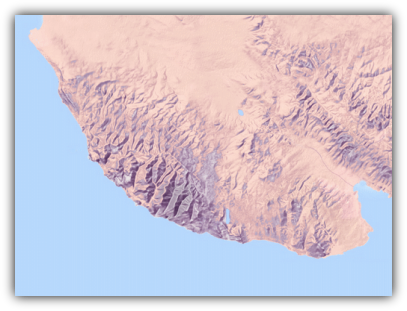
The Abrau Peninsula is located in the north-western spurs of the Greater Caucasus Mountain Range, in the north it is bounded by the river valley of the Kotlama river, from the east – by the Markotkhsky ridge, to the south and west – by the Black Sea. On the territory of the peninsula stands the south-west part with its middle relief, passing into the depth of the continent and in the lowland and slightly hilly. There is no doubt that it is exactly natural and geographical conditions play a decisive role in many respects in the settlement spread.
The relief of the region renders a great influence on the formation of settlement systems and management. In mountainous areas, it is often due to the geological structure and history of geological development. The geological structure of the Abrau Peninsula involved Cretaceous and Paleogene sediments. The section mainly consists of rhythmically interbedded limestone, marls, siltstones, argillites, sandstones and clays-less.
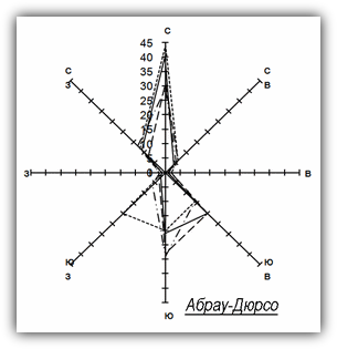
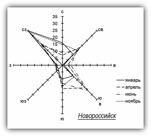
The climate of the Abrau Peninsula is mild with a positive average annual temperature of air and soil. The relief has a significant impact on the change of climate characteristics at different places of the peninsula. Besides, the average annual rainfall, according to meteorological stations changes as follows: Gastogaevskaya ‒ 477 mm, Krymsk ‒ 657 mm, Anapa ‒ 452 mm, the Markotkh pass ‒ 731 mm, Novorossiysk ‒ 724 mm, Abrau-Durso ‒ 643 mm, the Doob lighthouse ‒ 565 mm. As a result, hydration in different regions varies by more than 1.5 times. A characteristic feature of the climate in the area of Novorossiysk are strong north-eastern winds (northeast) mainly observed in autumn and winter, when it runs to 50 m/s with highly drop in temperature. The northern part of the peninsula, where Raevskaya and Natukhaevskaya are located, they are almost not affected
(Ol’ga E. Vyazkova).